

The devastation caused by torrential rains and flash floods in and around Hyderabad this week is another grim reminder of the havoc played with the chain of lakes and storm water drains that were working as a natural flood control system.
This is not the first time the city has witnessed flooding but every time in the recent period, it faced nature’s fury, it failed to learn a lesson.
 Flooding of roads and inundation of low-lying areas are a common sight in the city whenever it rains heavily. Every time it is brushed aside either as a natural occurrence or inevitable consequence of the rapid development the tech hub is witnessing.
Whenever the city faced flash floods, those in power form committees comprising officials and experts to suggest measures to prevent recurrence. However, reports of these panels, containing almost similar suggestions, are gathering dust.
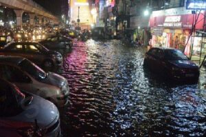
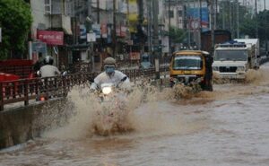
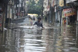
The extremely heavy rainfall of October 13 triggered a deluge in not just the outskirts but also in the heart of the city. More than 30 people lost their lives and about 2,000 colonies were inundated.
The last time the city had witnessed such massive floods was some 20 years ago. Rainfall of 24.5 cm on August 24, 2000 had caused the deluge.
As the city has expanded by leaps and bounds to become Greater Hyderabad, the rainfall at some Automatic Weather Stations (AWS) installed by the Telangana State Development Planning Society was much higher than 24.5 cm. The AWS at Hayathnagar, for instance, recorded over 29 cm rainfall in 24 hours ending 5 a.m. on October 14.
India Meteorological Department (IMD), however, maintained that the city recorded an average 19.2 cm rainfall. Irrespective of the rainfall amount, the scale of flooding and devastation caused by the latest flooding is unprecedented.
Many of the colonies submerged had either come up on lake beds or close to the lakes. Heavy rainfall led to breach and overflow of the lakes, which shrunk in size over the last 2-3 due to encroachments and construction activity.
 Appa cheruvu, for instance, was spread over six acres. Now the lake has shrunk to two acres. Its embankment collapsed following heavy rains of October 13 and caused massive flooding in Gaganpahad area, inundating houses and the Hyderabad-Bengaluru highway.
Historians say Hyderabad’s founder Muhammad Quli Sutb Shah and subsequent Qutb Shahi and Asaf Jahi rulers with their foresight had developed and promoted a system to prevent flooding even in the highest rainfall.
The system comprised a chain of lakes, channels connecting lakes to the river, open spaces and swamp areas to suck in rain water and storm water drains.
The city was founded on the banks of Musi river, which was the lifeline of the city. After devastating floods in Musi killed thousands of people in 1908, the government of then Nizam built new reservoirs upstream and developed a new drainage system to prevent recurrence of floods.
The water bodies, channels and storm water drains, popularly known as nalas, were further improved.
“The city had a very good drainage system. Whenever it used to rain, the inflow and outflow channels drain down north and south basins into Musi river. Since those channels have been destroyed, water can’t drain into the river. So water is there everywhere,” explained Lubna Sarwat, an activist fighting for preservation of lakes.
She pointed out that lakes supposed to hold water were severely restricted in terms of both surface area and holding capacity due to both official and private encroachments.
“Dumping of waste including construction material has further curtailed the holding capacity. Since the lakes can no longer hold water, it is on roads and colonies,” said Sarwat, who earlier worked as convenor of Save Our Urban Lakes.
According to the Forum For A Better Hyderabad, a group comprising environmentally conscious individuals and organisations, the city was home to 3,000 to 7,000 natural and manmade water bodies such as lakes, ponds, tanks and other reservoirs.
Over the years, however, most of these water bodies have disappeared. According to the Forum, studies have suggested that since the 1990s, Hyderabad has lost over 3,000 lakes.
 “Even till 1970, we had the balance. Post 1970, there was a frightening imbalance in the planning as people from all over the state started coming to the city. People started moving into the city knowingly or unknowingly and converted water bodies into buildings,” says heritage activist P. Anuradha Reddy, who earlier headed Society for Preservation of Environment and Quality of Life (SPEQL).
After the floods of 2000, the then government had constituted a committee to suggest measures to improve nalas. The committee, in its report, identified 28,000 encroachments and estimated that removing them and improving the nala system required Rs 10,000 crore. The report was kept aside as its implementation was perceived impossible.
Another committee for expansion and modernization of nalas was formed in 2007. It gave a report which was similar to the previous panel and met the same fate.
Subsequently, another panel of experts suggested various measures to improve nala and restoration of lakes but its report too is gathering dust.
On the other hand, the Telangana chief minister K. Chandrasekhar Rao (KCR) has touted Hyderabad as a ‘global city’, the capital was hit by flash floods earlier this week and has remained cut off from the rest of the world after major roads were washed away. Experts have attributed this turn of events to poor urban planning, a woeful drainage system and the pitiable condition of the Musi river, multiple streams and water-storage tanks, as a result of unplanned urbanisation.
 Most parts of Hyderabad lost power and internet connectivity for two days following the floods. The state government has already estimated the losses to amount to Rs 5,000 crore. In a letter to Prime Minister Narendra Modi, chief minister KCR sought immediate relief of Rs 1,350 crore from the Centre.
Although official figures aren’t yet available, reports suggest the floods have already claimed more than 50 lives in the state as well as have left thousands homeless (as on October 16 morning). Hyderabad MP Asaduddin Owaisi, a member of the All India Majlis-e-Ittehadul Muslimeen (AIMIM), said in a tweet on October 14 that a boundary wall (of some sort) had also collapsed in the Mohammedia Hills part of the city, killing nine people and injuring several others, many critically so.
Some parts of the city reportedly received 32 cm of rain in 24 hours – the highest in a century. According to unofficial accounts, multiple teams of the National Disaster Response Force and army personnel have set out by boats to evacuate stranded people.
The last time the city saw serious flooding was in August 2000, with rainfall of 24 cm in a single day, claiming 15 lives. In 1908, the River Musi was in deluge, subjecting leading to as many as 15,000 deaths. This calamity prompted the government to rope in veteran irrigation expert Mokshagundam Viseswarayya for a study on flood mitigation. Osman Sagar and Himayat Sagar were built to act as flood control centres as a result of the expert’s recommendations. But one of his vital recommendations – a modern drainage system – still remains a dream.
According to K.J. Ramesh, former director general, Indian Meteorological Department (IMD), urban flooding occurs due to the incapacity of the city to handle rainwater during extreme rainfall events. Speaking to The Wire, Ramesh underlined the need to build climate-resilient infrastructure in cities on a priority basis, as a deterrent against disasters of this kind.
Hyderabad is endowed with a system of catchments. Its western edges are in the Godavari river basin (from Kukatpalli, Ramachandrapuram to Gachibowli) while its eastern part is in the Krishnaa river basin. The Deccan region as a whole has a chaotic drainage pattern – water does not flow in a single direction, as the slope moves in multiple directions.
 In a 2016 report, the Centre for Science and Environment estimated that in the last 12 years, Hyderabad has lost 3,245 hectares of wetlands. The report further said that urban water bodies have been a victim of unplanned urbanisation, facing serious threats such as encroachments, disposal of sewage and groundwater decline.
The Telangana Rashtra Samithi government headed by KCR established the Musi Riverfront Development Corporation and gave it Rs 1,665 crore in 2017, with the express objective of cleansing the river of encroachments and effluents. But the mission failed to move forward, though the corporation has paid Rs 3.15 crore in salaries annually nonetheless. A survey undertaken by the corporation revealed that the river that criss-crosses the city is cluttered with 12,000 encroachments in the form of structures of varying sizes. The decision to remove such encroachments is in limbo for want of permission from the government.
The government’s ‘lopsided’ priorities have been blamed for the nightmares the city is currently passing through. C. Ramachandraiah, a professor at the Hyderabad-based Centre for Economic and Social Studies, told The Wire that the TRS government in the last six years of rule only focused on flyovers and bridges, and actively made way for rapid urban development with a scant regard for flood mitigation plans in the city.
The course of the Musi river has been narrowed at many places in the city because of encroachments. Its path has to be straightened by removing high-rise buildings that came up on the river bunds to make way for free flow of waters. The government should prepare itself to relocate and rehabilitate the dwellers residing on the river bunds, Ramachandraiah said.
Nalas (streams) and drainage channels are getting choked with construction debris, and domestic and industrial waste, causing flooding, he added.
Everyone is complicit in making public life miserable in Hyderabad, says civil society member Raka Sudhakar. Governments in the past and present have been choosing nalas as ideal places for implementing housing schemes for the urban poor. The erstwhile Congress government proposed to build houses under the Rajiv Griha Kalpa along the course of nalas, and the present TRS government too has planned two BHK flats at the same places, Sudhakar pointed out.
 People making a living on encroachments on tanks and nalas in the city are estimated to be between seven and ten lakh. That over 1,000 colonies were effected by the recent floods points to the volume of encroachments. No party, apparently, can afford to antagonise such a large number of people before elections for the Greater Hyderabad Municipal Corporation scheduled in November.
Corporate hospitals and even luxury hotels have been allowed to come up on nalas, with impunity. Necklace Road was built on nine channels that bring sewage water into the Hussain Sagar lake from different parts of the city, but these channels are reportedly now narrow as a result of road building.
During floods, waters flow in the opposite direction, thereby flooding vulnerable areas for want of an outlet at the mouth of the lake. The authorities reportedly narrowed the outlets with meshes so as to prevent garbage and other waste from entering the water body.
Telangana State Pradesh Congress Committee (TSPCC) president N. Uttamkumar Reddy and BJP Union minister of state for home G. Kishen Reddy held the TRS regime squarely responsible for the city’s plight. Kishen Reddy said the KCR government turned a blind eye to its own agenda of the Musi Riverfront Development Project.
TRS’s urban development minister K.T. Rama Rao, in turn, taunted the Union minister, asking why he failed to bring sufficient funds from the Centre for city development. And so, the blame game goes on till the upcoming municipal elections. #KhabarLive #hydnews
Related Links:


[…] में 3000 झीलें थीं, लेकिन बहुत कम समय में अब बहुत कम बची हैं या फिर कचरे से पट चुकी […]
[…] में 3000 झीलें थीं, लेकिन बहुत कम समय में अब बहुत कम बची हैं या फिर कचरे से पट चुकी […]
[…] में 3000 झीलें थीं, लेकिन बहुत कम समय में अब बहुत कम बची हैं या फिर कचरे से पट चुकी […]
[…] में 3000 झीलें थीं, लेकिन बहुत कम समय में अब बहुत कम बची हैं या फिर कचरे से पट चुकी […]
[…] items and food stocks were damaged in several houses, many business establishments operating in low-lying areas also suffered huge […]
Comments are closed.